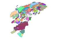
From north to south of the province there is a clear variation of the different aquifers’ characteristics based on geology :
– In the northern area, where high-permeability materials abounds (highly fractured limestone and dolomites), aquifers have optimal features for exploitation (Almudaina-Segaria, Albuerca-Mustalla, Carrascal-Bernia, Solana. Pinar de Camus, Aitana).
– Southward, more impermeable materials (with the presence of marl and clay) and greater structural complexity results in small-scale aquifer and less optimal hydrogeological characteristics (Anticlines of Orcheta, Monnegre, Ventós-Castellar, Albabor, etc.).
In the areas of “Vega Baja”, “Bajo Vinalopó” and “Alicante”, the aquifer formations consist of sandy materials and fragile limestone with few resources and quality.
The average net recharge in permeable outcrops in Alicante is 197mm/year, but shows very pronounced oscillations, from hardly 10mm/year in heavy clay aquifers, as in the “Valle del Serpis” or “Racó” ones, to values higher than 300mm/year, as in some aquifers in the south Albuerca Mustalla, Mediodía o Vergel. The total groundwater resources of the county aquifers have been estimated to be ca. 454 hm3.
Overall, the groundwater resources quality is good and even excellent in large areas of “Marinas”, “Comarca de Alcoy”, “Hoya de Castalla” and “Alto Vinalopó”. The worst quality corresponds to the southern half of the province and some aquifers in connection with the sea that are experiencing saltwater intrusion phenomena.
Vulnerability to contamination of aquifers: Water quality is the set of physical, chemical and biological water features that makes it suitable or unsuitable for a particular use.
Groundwater is generally better protected from pollution than surface water. However, once a pollutant is incorporated into the groundwater flow, its treatment is very costly. The best measure to maintain good water status, and especially groundwater, is to avoid contamination. For this reason, it is essential to know the degree of vulnerability to contamination of the different aquifers in Alicante and use this knowledge to define land use policies and establish measures to mitigate as much as possible the potential impacts.
The provincial council of Alicante has promoted and posted the Map of Aquifers Vulnerability to Contamination for the province, using the DRASTIC method, which assesses the groundwater vulnerability to contamination based on a series of factors: Depth of the water table, net recharge, aquifer media characteristics, soil characteristics, topography, impact of the vadose zone and aquifer hydraulic conductivity.
This map is an example of the interest of Alicante’s society by having water resources that meet their needs without giving up a healthy environment.