
From the Area of Hydrologic Cycle we use to explain how Hydrology (science which studies underground water) helps us to garantee lots of provincial supplies. Today we share this fragment of the article ‘Why Hydrogeology Plays Such An Important Role In The Thailand Cave Rescue Operations’ which explains the hydrogeology of the thailand cave:
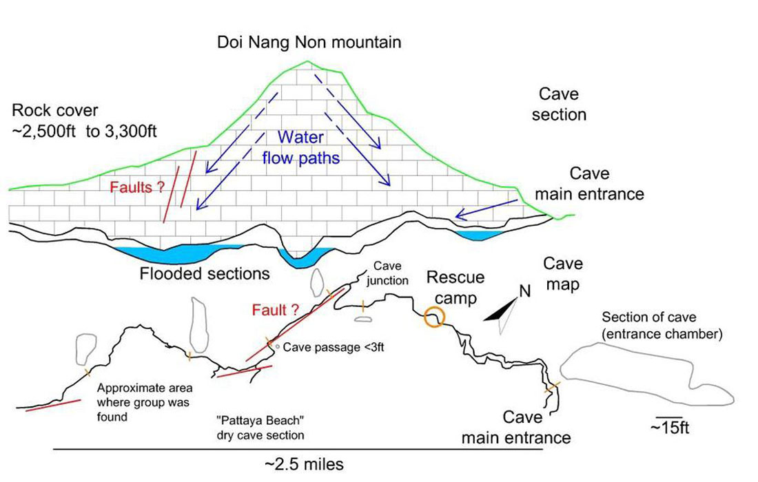
‘Water plays an important role in the formation of Thailand’s caves (see also this article on The Science Behind Thailand’s Unstable Caves), but it is also by far the most dangerous element when exploring wild cave systems. According to the geological map of Thailand the Doi Nang Non mountain range is composed of a succession of sandstone, limestone, shale and chert. Limestone is a sedimentary rock, vulnerable to tectonic deformation and erosion by water. Water enters the mountain following superficial cracks and faults. As limestone is dissolved by this groundwater, a three-dimensional network of caverns and conduits forms over time. Such karst systems act like a natural sponge inside the mountain. During some days of good weather, the cave appears completely dry.
In fact, during the dry season (September-June), Tham Luang cave can be easily reached on foot (even if it is forbidden to enter the cave). As soon as the cave’s entrance flooded after a flash flood, the group was forced to venture deeper inside the cave. A strong rainstorm is sufficient to flood also the inner network as the water, flowing in open cracks and conduits, can travel up to 1,000 ft through the porous limestone-rock in less than one hour.’
For further information, click on the picture below to access the full article: